


Precinct 1, Valley County, Nebraska
About
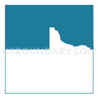
Outline

Summary
| Unique Area Identifier | 613994 |
| Name | Precinct 1 |
| County | Valley County |
| State | Nebraska |
| Area (square miles) | 257.73 |
| Land Area (square miles) | 256.20 |
| Water Area (square miles) | 1.54 |
| % of Land Area | 99.40 |
| % of Water Area | 0.60 |
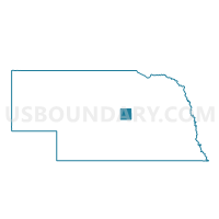
| Latitude of the Internal Point | 41.65974310 |
| Longtitude of the Internal Point | -98.99317490 |
Maps

Graphs
Select a template below for downloading or customizing gragh for Precinct 1, Valley County, Nebraska


Neighbors
Neighoring Voting District (by Name) Neighboring Voting District on the Map
- Voting District 2P, Wheeler County, NE
- Comstock Precinct, Custer County, NE
- Corner Precinct, Custer County, NE
- Greeley Voting Precinct, Greeley County, NE
- Precinct 4, Valley County, NE
- Precinct 5, Valley County, NE
- Precinct 6 - Ord, Valley County, NE
- Precinct 7, Valley County, NE
- Rural 1 Precinct, Garfield County, NE
- Scotia Voting Precinct, Greeley County, NE
Top 10 Neighboring County Subdivision (by Population) Neighboring County Subdivision on the Map
- Ord township, Valley County, NE (2,487)
- Greeley precinct, Greeley County, NE (745)
- Scotia precinct, Greeley County, NE (555)
- North Loup township, Valley County, NE (429)
- Rockford precinct, Garfield County, NE (299)
- Ericson precinct, Wheeler County, NE (260)
- Willow Springs precinct, Garfield County, NE (211)
- Elyria township, Valley County, NE (176)
- Comstock township, Custer County, NE (155)
- Enterprise township, Valley County, NE (113)
Top 10 Neighboring Place (by Population) Neighboring Place on the Map
Top 10 Neighboring Unified School District (by Population) Neighboring Unified School District on the Map
- Ord Public Schools, NE (3,531)
- Burwell Public Schools, NE (2,036)
- North Loup Scotia Public Schools, NE (1,120)
- Sargent Public Schools, NE (998)
- Wheeler Central Schools, NE (772)
- Loup County Public Schools, NE (639)
Top 10 Neighboring State Legislative District Upper Chamber (by Population) Neighboring State Legislative District Upper Chamber on the Map
Top 10 Neighboring 111th Congressional District (by Population) Neighboring 111th Congressional District on the Map
Top 10 Neighboring Census Tract (by Population) Neighboring Census Tract on the Map
- Census Tract 9717, Custer County, NE (2,721)
- Census Tract 9709, Greeley County, NE (2,538)
- Census Tract 9714, Valley County, NE (2,365)
- Census Tract 9732, Garfield County, NE (2,049)
- Census Tract 9713, Valley County, NE (1,895)
- Census Tract 9736, Wheeler County, NE (818)
Top 10 Neighboring 5-Digit ZIP Code Tabulation Area (by Population) Neighboring 5-Digit ZIP Code Tabulation Area on the Map
- 68862, NE (3,007)
- 68823, NE (2,401)
- 68874, NE (956)
- 68875, NE (658)
- 68859, NE (509)
- 68637, NE (267)
- 68828, NE (240)
- 68837, NE (103)